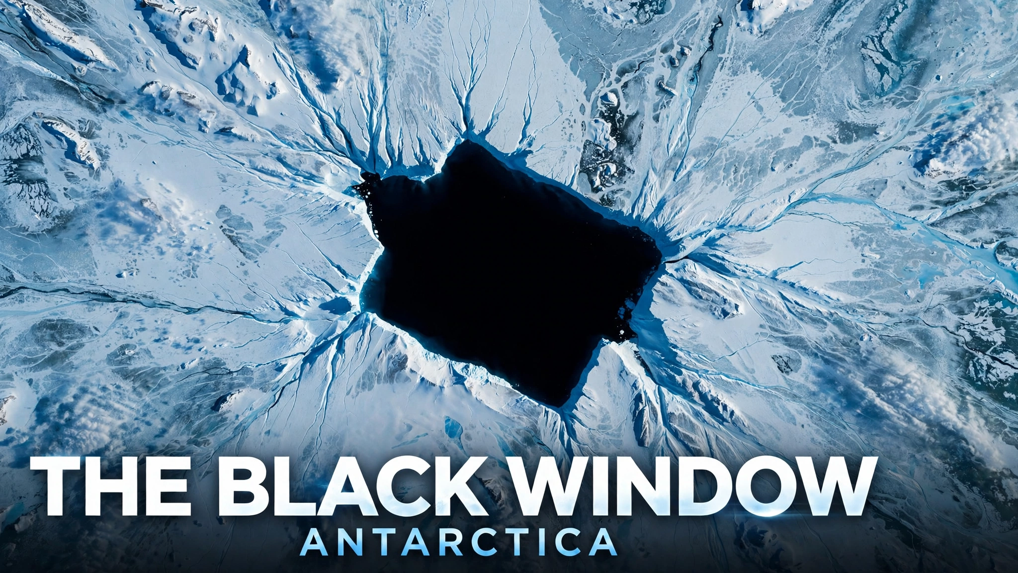
Antarctica. The white continent, the harshest land on Earth, where average temperatures can fall below minus 50 degrees. Near the coast of Queen Mary Land in East Antarctica, imagery on Google Earth has captured a black window.
A cavity of pitch black, smooth and geometric, clearly different in character from the cracks in the ice (crevasses) around the cavity. Online, rumors spread that the cavity might be a loading entrance to an underground base, or an entrance to something hidden under the ice. Earlier accounts estimated the size at about 30 meters high and about 90 meters wide, and described the scale as large enough for a large transport aircraft to enter just as it is. This size, however, is an estimate from earlier accounts, and is not a surveyed value.
Around these coordinates, however, lies another history. In 1946, the United States Navy sent as many as 4,700 personnel to Antarctica in Operation Highjump. And there is the rumor of Base 211, a secret Antarctic base of Nazi Germany. The white continent has long been made into a place where secrets are stored.
This article preserves the fragments of the rumor with care, and records the rumor together with knowledge from glaciology and with the reality of Antarctica as a place. At the end, the article also records what going to these coordinates would mean, together with the reality of cost.The romance of Antarctica is not completed by rumor alone. Only with the reality of cold and of cost does the romance become real.
- Observing the Window into the Abyss on Google Maps
- Record of the Black Window
- Operation Highjump — 4,700 Personnel Landed in Antarctica in 1946
- Neu-Schwabenland and the Rumor of Base 211
- A View From Glaciology — Nature Also Makes Entrances
- Our Reading — Antarctica as a Window into the Abyss
- In the Area
- What to Eat
- From Ushuaia — The Road to the End of the World and the Reality of Cost
- Fragments Assembled
- Sources & Further Reading
Observing the Window into the Abyss on Google Maps
Open the satellite imagery at the observation point carried over from earlier accounts. On the canvas of the pure white ice sheet, a black cavity should be visible, gaping open. Zoom in again and again and follow the shading, and the form can be confirmed as something different from the crevasses around the form.
One point deserves care here. Satellite imagery of Antarctica changes expression with every update. The same coordinates can look entirely different depending on the cover of snow, the altitude of the sun, and the presence or absence of cloud. An expression in earlier accounts, that the shading deepens with every observation, captures the psychology of the viewer well, but a change in imagery does not necessarily mean a change in the landform.
Record of the Black Window
When these coordinates spread online, observers of Google Earth around the world were astonished. On an ice sheet of solid white, a cavity had opened that was too black and too smooth. Was the cavity a chance product of nature, or a hole opened so that something hidden under the ice could breathe?
Earlier accounts described this cavity as looking like a deliberate entrance, and emphasized the geometric stability of the shape. In comparison with the rough cracks in the ice around the cavity, the entrance of this cavity is smooth and too complete. That impression called forth theories of an underground base and of a secret facility.
A calmer view also exists. The ice sheet of Antarctica holds countless strange landforms made by wind and by melting. As a later section examines in detail, a mysterious doorway that became a topic of discussion in 2024 at other coordinates in East Antarctica was explained by glaciologists as a grounded iceberg. A form that looks black is not necessarily a hole or an entrance.
In addition, the talk of a magnetic anomaly and of a blind spot for satellites, raised in earlier accounts, is unverified information, and no confirmable source has been found.The talk is preserved as a record of rumor, but is not treated as fact. That is the basic stance of this article.
Operation Highjump — 4,700 Personnel Landed in Antarctica in 1946
When mysterious structures in Antarctica are discussed, one historical fact is always cited. The fact is Operation Highjump, a large Antarctic observation project carried out by the United States Navy from 1946 to 1947.
The formal name was The United States Navy Antarctic Developments Program, 1946–1947. Rear Admiral Richard E. Byrd directed the operation as a whole, and Rear Admiral Richard H. Cruzen commanded the fleet (Task Force 68). The operation began on August 26, 1946, and ended in late February 1947, at a scale of 4,700 personnel, 13 ships, and 33 aircraft. The operation was one of the largest military expeditions in the history of Antarctic observation.
The official purposes were the establishment of the Antarctic observation station Little America IV, training of personnel and equipment in cold regions, and wide-area survey by aircraft. The results were also solid. Over 70,000 aerial photographs were taken, and an area of over 1.5 million square miles was surveyed. The Secret Land, the documentary film of the expedition, received the Academy Award for Documentary Feature in 1948.
Why, then, is this operation linked with mystery? One reason is the strong military character of the operation. The forces committed were far too large for a simple scientific survey. Another reason is the end of the operation. Officially, the early arrival of winter and worsening weather are given as the reasons, but some rumors hold that the withdrawal came earlier than planned, and a theory circulates that an encounter with an unknown presence lay behind the withdrawal.
August 26, 1946, to late February 1947. Carried out as an Antarctic development program of the United States Navy.
Rear Admiral Richard E. Byrd directed the operation as a whole, and Rear Admiral Richard H. Cruzen commanded the fleet (Task Force 68). A force of 4,700 personnel, 13 ships, and 33 aircraft was committed.
Establishment of the Antarctic observation station Little America IV, training in cold regions, and aerial survey. The operation left results of over 70,000 aerial photographs and survey of over 1.5 million square miles.
The official reasons for the end were the arrival of winter and worsening weather. The Secret Land, the documentary film of the expedition, received the Academy Award for Documentary Feature in 1948. Talk of a mystery of early withdrawal and of an encounter with an unknown presence remains unverified rumor.
A distinction deserves care. Operation Highjump itself is historical fact, but the talk that the operation is hiding something is rumor.The fact of a giant military expedition has become fuel for the imagination.
Neu-Schwabenland and the Rumor of Base 211
One more element is indispensable to legends of a secret base in Antarctica: the shadow of Nazi Germany. From 1938 to 1939, a German Antarctic expedition named a part of East Antarctica Neu-Schwabenland and claimed possession of the land. That claim is a historical fact that actually took place.
Derived from that claim is the rumor that a secret stronghold called Base 211 was built under the ice of Antarctica. Speculation never ends that the hole at these coordinates might be a loading entrance to that underground base. Earlier accounts note that the geometrically ordered shape carries an eerie persuasiveness as an artificial structure.
One point, however, is stated plainly here. No confirmable historical material shows the existence of Base 211.The claim of possession of Neu-Schwabenland is historical fact, but construction of a secret base does not leave the realm of unverified rumor. Rumor piles up on top of historical fact, and in time the rumor is told like a darkness of history. That pattern is also a typical process of growth for an urban legend.
A View From Glaciology — Nature Also Makes Entrances
How, then, does science view unnatural landforms of this kind? The ice sheet of Antarctica is richer in expression than imagination suggests. Strong wind, melting, and refreezing produce many landforms that resemble artificial structures.
The first form to know is the nunatak. A nunatak is a mountain peak or an exposure of rock that protrudes from a glacier. Katabatic wind, a strong wind that blows down a slope, blows the surrounding snow away, and dark rock is exposed. Seen from above, the form can easily look like a black window opened in a pure white canvas.
A recent example also remains in memory. In 2024, at other coordinates in East Antarctica, southeast of Showa Station of Japan, a landform like a mysterious doorway was found on Google Maps and became a major topic online. Theories that the form might be an entrance to an underground base also flew about.
The scholar who settled this affair was Professor Bethan Davies, a glaciologist at Newcastle University in the United Kingdom. As a result of examination of past imagery in Google Earth Pro, this doorway was found to be an iceberg that had run aground and was melting in place. Professor Martin Siegert of the Grantham Institute also explained the form as a product of the flow of ice around a hard obstacle under the ice sheet, affected by melting and refreezing and by katabatic wind. What looked like a doorway was a joint work of ice and wind.
A further example of a giant hole opened by nature is the polynya of the Weddell Sea. From 2016 to 2017, a giant hole opened in the sea ice of the Weddell Sea in Antarctica. The hole reached a maximum of about 80,000 square kilometers, and scientists also puzzled over the hole at first. Later research clarified that the hole opened through a combination of Maud Rise, a seamount on the sea floor, and a movement of seawater called Ekman transport. Nature can open holes at a scale beyond human imagination.
An exposure of rock that protrudes from a glacier. Katabatic wind blows the snow away, and dark rock appears. From above, the form can look like a black window.
The doorway-like landform that became a topic of discussion at coordinates southeast of Showa Station was found, through investigation by Professor Bethan Davies of Newcastle University, to be a grounded iceberg.
A giant hole that opened in sea ice in 2016–2017. Maximum about 80,000 square kilometers. Research has clarified the cause as Maud Rise on the sea floor and Ekman transport.
Hundreds of subglacial lakes are known to exist under the ice sheet of Antarctica, Lake Vostok among the lakes. A unique environment isolated for millions of years is sometimes called another world within the planet.
This knowledge strongly suggests a possibility that the cavity is a product of nature. At the same time, another statement also holds. Landforms made by nature can be stranger than artificial structures.That fact itself may be the deep appeal of Antarctica.
Our Reading — Antarctica as a Window into the Abyss
Earlier accounts viewed this hole as a bug for heat exchange in the giant system of the Earth. Perhaps geothermal heat and unknown gas released from subglacial lakes and from cavities in the crust keep melting the ice above. The romance of this idea is beautiful beyond the presence or absence of scientific support.
In the archive of this site, these coordinates are recorded as a vent of the planet. Somewhere on the white continent, ice is breathing. The sound of that breathing has reached human imagination through Google Earth, an eye of a god.
The 4,700 personnel of Operation Highjump, the claim of possession of Neu-Schwabenland, and the rumor of Base 211. All of these elements form strata of human stories piled up around these coordinates. Even if the true nature of the landform proves to be a product of nature, those strata will not disappear. Antarctica continues to serve as a white vault that holds human imagination in trust.
Knowledge of a true nature and disappearance of a wondrous impression are not the same matter. Even after the mysterious doorway of 2024 was found to be an iceberg, the stir felt on seeing that image does not disappear. A mystery of fact and a mystery of sensation are separate matters. The former can be confirmed in materials. The latter is born in the experience and imagination of a person who has seen the form.
In the Area
No tourist facilities exist around these coordinates. The coast of Queen Mary Land lies in East Antarctica, far from the routes of tourist cruises. Antarctic tourism itself, however, does exist. Representative places visited on cruises toward the Antarctic Peninsula are introduced here as a world that lies before a journey to these coordinates.
Representative ports of call on the Antarctic Peninsula. Colonies of penguins can be seen against a background of glaciers, and cruising by Zodiac boat is offered.
A ring-shaped island formed by volcanic activity. The interior of the bay forms a natural harbor, and remains of a former whaling station survive. The island is also known as a rare place in Antarctica where bathing in hot springs is said to be possible.
An island with a large colony of Gentoo penguins. The island offers one of the symbolic landscapes of Antarctic tourism.
Adelie penguins, Emperor penguins, humpback whales, and seals. The leading figures of Antarctic tourism are ice and living creatures.
These sightseeing places and the coordinates of this article are related only within the broad frame of the same Antarctic continent, and do not lie near each other. East Antarctica, where the coordinates lie, and the Antarctic Peninsula, where tourist routes run, are thousands of kilometers apart.
What to Eat
No restaurants exist on the Antarctic continent. The place for enjoyment of meals on the ice is aboard an expedition ship. Even so, the port towns that serve as starting points for a journey to Antarctica hold flavors unique to the land.
On an expedition ship of an Antarctic cruise, meals during the voyage are provided. A meal taken while viewing a sea of ice is carved deep into the memory of a journey.
In Ushuaia in Argentina, the port of departure, Argentine meat dishes (asado), king crab (centolla), and Patagonian lamb are known. A meal in a port town at the end of the world also forms part of a journey.
In wintering life of Antarctic observation teams, ingenuity with limited ingredients has become a tradition. Tourists do not experience that life, but the food culture of polar regions deserves knowledge.
Business conditions, prices, and menus of shops change over time. For that reason, shop names and business hours that cannot be confirmed as real are not listed here.
From Ushuaia — The Road to the End of the World and the Reality of Cost
What would going to these coordinates mean? The account begins with the reality of Antarctic tourism. The only realistic means for an individual traveler to reach Antarctica is an expedition cruise starting from Ushuaia in Argentina (or from Punta Arenas in Chile). Beyond that point lies a wall of cost.
The southernmost city in the world. A journey begins from a port at the end of the world. International visitors generally reach Ushuaia via Buenos Aires or through other hubs, with onward domestic flights in Argentina.
Head toward the Antarctic Peninsula and the South Shetland Islands. A voyage of 11 to 12 days is standard, with landings by Zodiac boat included.
Rough seas for about 2 days. The passage is held to be one of the roughest sea areas in the world, and the crossing is sometimes called a baptism of seasickness.
Travel by Zodiac boat to a land of ice. A world of penguins and icebergs opens out. As far as this point, any traveler can arrive, provided the cost can be prepared.
Queen Mary Land in East Antarctica lies thousands of kilometers from the tourist routes of the Antarctic Peninsula. A regular cruise cannot reach the land. No commercial means of reaching these coordinates can be confirmed.
In a price list of a Japanese agency for Antarctic travel (2026-27), an 11-day course starts at US$13,995 and a 12-day course starts at US$11,275. A 15-day course starts at US$15,665, and a 20-day course starts at US$23,335. None of the prices includes international airfare.
With an assumed exchange rate of 150 yen to the dollar, the cruise fare alone comes to about 1.7 million yen and up. Combined with round-trip airfare to Ushuaia (typically several hundred thousand yen), the total will likely exceed 2 million yen.
The figures above are the cost of a tourist cruise to the Antarctic Peninsula, and are not the cost of reaching coordinates in East Antarctica. No commercial means of reaching the coordinates can be confirmed, so no estimate of cost is possible. If a charter for a polar expedition or a similar arrangement were required, the scale would bear no comparison with a tourist cruise.
The amounts above are an example based on a price list of one agency for the 2026-27 season, and vary with exchange rates, fuel prices, and fare revisions. The rate of 150 yen to the dollar is an assumed rate. Airfare to Ushuaia varies greatly with season and route. No commercial means of reaching the coordinates in East Antarctica has been confirmed, and both the feasibility of arrival itself and the cost remain impossible to estimate. That point is stated explicitly here.
Antarctica is administered under the Antarctic Treaty and the Madrid Protocol on Environmental Protection, and military activity, environmental destruction, and entry without permission are strictly restricted. Unauthorized exploration by an individual could develop into an international problem. Extreme cold of tens of degrees below zero, blizzards, and hidden crevasses make entry without preparation a matter of life and death. For Antarctic tourism, choose an operator that follows the guidelines of IAATO, the industry association.
To summarize. Merely to stand on the Antarctic Peninsula, a cruise from Ushuaia will likely exceed 2 million yen. To East Antarctica, where this land lies, however, no tourist ship travels. A continent that seems reachable and coordinates where a person can stand do not coincide.That gap itself may keep these coordinates a window into the abyss forever.
Fragments Assembled
The true nature of the black entrance in Antarctica was, in all likelihood, neither a loading entrance to an underground base nor a door of a secret facility. Nunataks, katabatic wind, grounded icebergs, and polynyas. Knowledge from glaciology teaches that the white continent produces unnatural landforms by natural means. That is the answer reached through investigation.
After knowledge of that answer, however, open the satellite imagery once more. The black cavity may still look as if the cavity were trying to convey something. Perfect darkness lies in the middle of an ice sheet, and no person can enter. Is that fact alone not fantastic enough?
On the map, darkness can still be read. Humanity once called Antarctica the end of the world, and wished that nothing lay beyond. The present age is an age in which satellites look down on the white continent and find a black window in the middle of the continent. To learn a true nature is not to lose a mystery. The shape of the mystery changes.
Sources & Further Reading
- Operation Highjump — Wikipedia — An outline of Operation Highjump (period, scale, commanders, and results)
- LADbible — The Mysterious Doorway of 2024, Explained — The grounded iceberg account by Professor Bethan Davies of Newcastle University
- Green Matters — The True Nature of the Mysterious Doorway in Antarctica — Views of Professor Siegert and Professor Smellie
- Gizmodo — The Giant Polynya of the Weddell Sea, Explained (2019) — Maud Rise and Ekman transport
- Antarctic Cruise Price List (2026-27) — Triwell International (polarcruise.jp) — An example of fares for courses departing from and returning to Ushuaia
- About Us — IAATO (International Association of Antarctica Tour Operators) — An outline of the industry association for Antarctic tourism
- National Institute of Polar Research (NIPR) — A public institution for Antarctic observation (cited in earlier accounts)