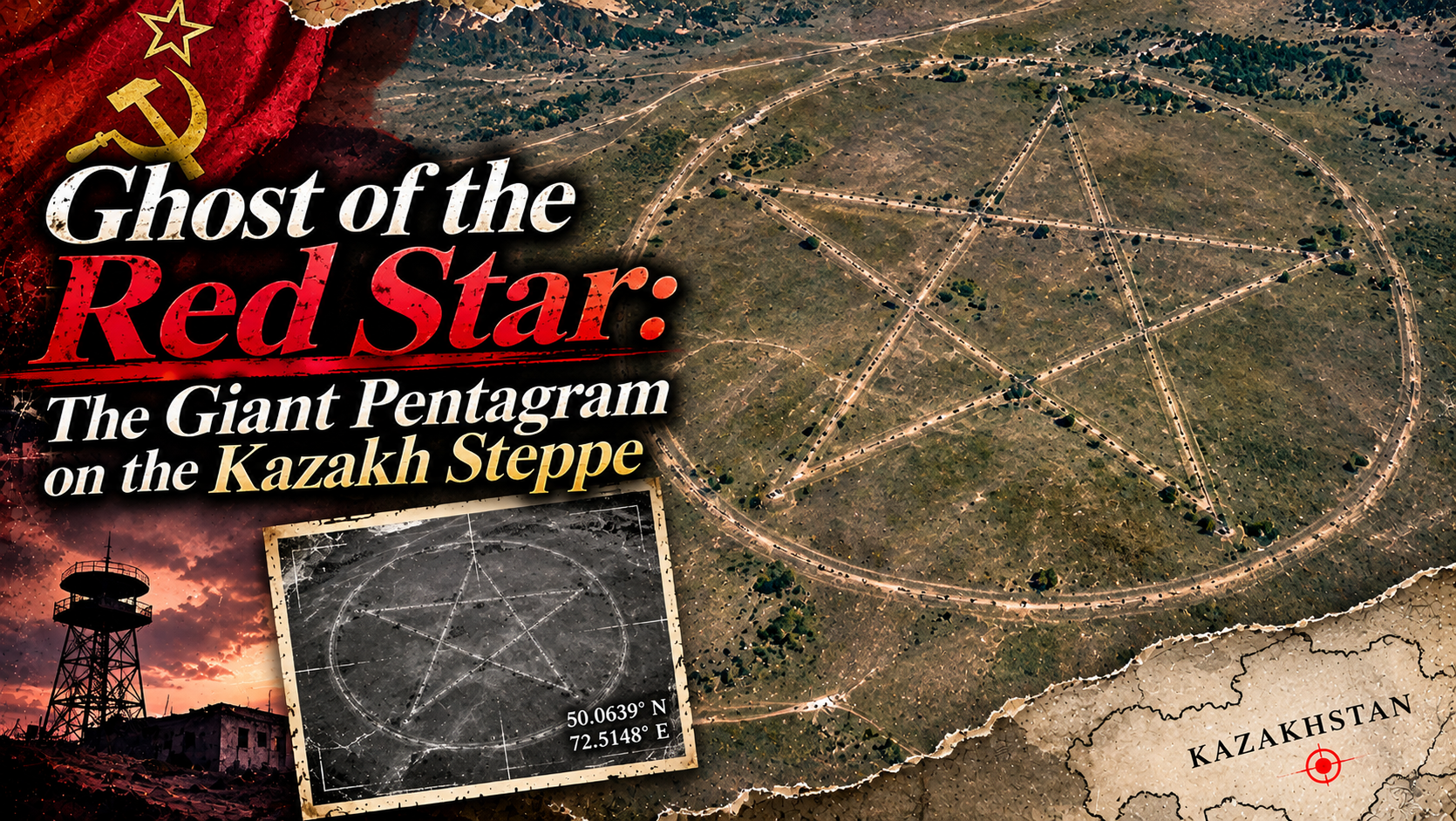
Along the boundary between steppe and water, a single line runs. The line breaks, turns at a sharp angle, and crosses another line. Pull the map back a little, and suddenly they become a single shape. A giant pentagram enclosed in a circle. On the shore of the Upper Tobol Reservoir in northern Kazakhstan lies a symbol that can hardly be read except from the sky.
Its diameter is about 366 meters — far beyond any comparison with a star drawn in a schoolyard. The shape standing out in the satellite imagery is too regular to look like a pattern nature happened to make. So who carved a star into this land, and for what purpose?
Online, interpretations circulated: a ritual site for devil worship, a secret military facility, an ancient emblem. An archaeologist who knows the area, meanwhile, saw an entirely different landscape there. The same star takes on a different meaning depending on the history its viewer carries. Let us follow this strange coordinate — across the map, and deep into the record.
- A Star Readable Only from the Sky — A Strange Object on the Map
- 2013: The Giant “Devil’s Mark” Spreads Across the World
- “Adam” and “Lucifer” — Another Story That Appeared on the Map
- The Military Facility Theory — Another Reading Born of Cold War Memory
- What the Archaeologist Saw Was a Park in the Shape of a Star
- The Age of the Red Star — Why Draw a Pentagram in a Park?
- An Older Time Sleeping Beneath the Star
- Paths on the Ground, a Symbol for the Sky — A Story That Changes with the Viewpoint
- In the Area: The Land of Lisakovsk
- What to Eat: A Taste of Life on the Steppe
- Getting There: To the Giant Pentagram — Imagining a Journey to the Star on the Steppe
- Fragments Assembled
- Sources & Further Reading
A Star Readable Only from the Sky — A Strange Object on the Map
This pentagram lies near the lakeshore of the Upper Tobol Reservoir, in the steppe country of northern Kazakhstan. The town most often named as the nearest is Lisakovsk, about 20 kilometers to the east. The photographs show few signs of people, but the surrounding area is not completely uninhabited land. There are roads and vegetation along the water, and in the distance, a town where people live.
Zoom in on the satellite imagery, and the star’s lines come to look less like a giant trench and more like the traces of roads and small paths. A circumference rings the outline, and the star’s points and intersections form a geometric figure. Walking on the ground, each of these paths might look like nothing more than a curving track. From above, though, the paths suddenly begin to carry “meaning.”
People search maps for mountain ranges, rivers, and borders. At this place, however, the first thing that leaps to the eye is a symbol. And the pentagram has worn many meanings through the ages — of religion, of magic, of the military, of the state. The story rises before any explanation of the terrain. That is the strangeness of this coordinate.
2013: The Giant “Devil’s Mark” Spreads Across the World
It was in 2013 that this star became an international topic. The giant figure, which can be seen on Google Maps and Google Earth, was taken up by news sites and occult blogs. In English-language reporting, provocative questions decorated the headlines: “a giant pentagram,” “could it be a mark of devil worship?”
Read the reporting of the time, and what matters is not only that a strange shape had been discovered. There was also a change in the times themselves: anyone could now zoom into satellite photographs from a screen at home and discover the shape of land once known only to the local people. Satellite imagery shows the landscape without attaching any explanation. The imagination of the internet filled in the blank that opened there.
Radio Free Europe/Radio Liberty reported in August 2013 that this pentagram had been widely shared on conspiracy-theory blogs and elsewhere, and had been taken up by overseas media as well. In other words, the story of the “devil’s star” is itself a record that mirrors the internet culture of the time.
“Adam” and “Lucifer” — Another Story That Appeared on the Map
The talk around this star holds a further, stranger fragment. Reporting in 2013 also made much of the fact that the names “Adam” and “Lucifer” appeared nearby on Google Maps. Adam is the first human in the Bible; Lucifer is a name that, in later Christian culture, became tied to the image of a fallen angel or a devil. As a coincidence, the pairing looks almost too good to be true.
But a name shown on a map is no inscription guaranteeing the history of a place. The information in a map service can undergo editing and updating, and what is displayed changes from one period to another. What is interesting here is that the names did not so much explain the star’s meaning — rather, the people who saw the star read the names as a new clue.
An unfamiliar giant figure, with unsettling names attached. From there, stories of secret societies, rituals, and entrances to another world connect one after another. A map is a tool for showing the surface of the earth, and yet at times it becomes a mirror that reflects human associations as well.
The Military Facility Theory — Another Reading Born of Cold War Memory
Devil worship was not the only theory told. The reporting of 2013 also records an example in which an internet user claiming to be a former military pilot speculated that the site might have been a Soviet surface-to-air missile facility. The vast territory of the former Soviet Union, Cold War military installations, land that ordinary people cannot approach — when images like these overlap, the giant star begins to look like a military marker, too.
However, from the reporting consulted for this article, we could not confirm any concrete facility records or drawings showing that a missile base existed at this place. We present the military facility theory as a single fragment indicating what kinds of speculation circulated at the time.
What is interesting is that the devil-worship theory and the military facility theory, although they are almost opposite stories, were born from the same photograph. Both are supported by the intuition that “something this large must have a purpose it would not want people to know.” The star says nothing. The viewers project onto it the anxieties of their own times.
What the Archaeologist Saw Was a Park in the Shape of a Star
What greatly changed the interpretation of this coordinate was the explanation of Emma Usmanova, an archaeologist who has long been active around Lisakovsk. In an interview with Live Science in August 2013, she described this figure as “the outline of a park in the shape of a star.” What draws the star, she said, is not a mysterious trench carved into the surface, but paths maintained in the past and the trees that grew along them.
This explanation also overlaps with the character of the lines seen in satellite photographs. Straight lines run in sequence, bend at angles, and have a width like a footpath. For a person walking inside the park they are paths for getting around, but seen from above as a design, they become a giant pentagram. A function on the ground and a symbol from the sky overlap in a single place.
And yet: in which year, and by whom, was it designed? How far did the construction advance, and when, and why did it cease to be maintained? No design drawings or administrative documents verifying details of that kind were found among the materials we were able to confirm. Some introductions describe it as a planned summer camp, but detailed records of use for a completed facility could not be confirmed. Explaining the outline and knowing the full history of the facility are separate matters.
The Age of the Red Star — Why Draw a Pentagram in a Park?
Until its independence in 1991, Kazakhstan was one of the republics that made up the Soviet Union. The five-pointed star, the red star above all, is a symbol that was widely used on the flag of the Soviet Union, on military insignia, on monuments, and on public buildings. While we today take the pentagram as an image of magic, in the public spaces of the Soviet era it was also a very familiar figure expressing the state and its ideals.
To take a star into the design of a park was probably not such an outlandish idea within the culture of the time. Children playing, families walking, spending a holiday by the water. If the paths made for such things had drawn the symbol of the state, there must have been a scene entirely different from the eeriness one now feels from the satellite imagery.
What we should note here is that scenes such as how many children once played there, or whether an opening ceremony was held, cannot be depicted as fact. What is certain is that the outline of paths, interpreted as a star-shaped park, remains, and that it resonates strongly with a symbol of the Soviet era. How far people’s lives actually entered the place is a history that still has blank spaces.
Archaeologist Emma Usmanova has explained that the figure is the outline of a star-shaped park. It has been reported that the trees along the paths make the lines stand out in the satellite imagery.
The way the facility is called varies — a park, an unfinished summer camp, a Soviet-era recreation facility, and the like. No primary sources that would settle its construction year, its managing body, or the circumstances of its abandonment could be confirmed.
An Older Time Sleeping Beneath the Star
The history of this land does not end with the Soviet era. The area around Lisakovsk is also introduced as a region where Bronze Age sites are known. Settlement remains, cemeteries, and features connected with burial — beneath the steppe, human activities far older than the modern state lie layered one over another.
That, however, is no basis for considering the giant pentagram itself a Bronze Age ritual site. What is rather more interesting is that traces of different eras are folded over one another in the same region. What ancient people left in the land, the paths laid out in the Soviet era, and the “mystery” that we of the twenty-first century discovered in satellite imagery.
Seen from the sky it is a single map, but beneath that map lie thousands of years. The pentagram is only a comparatively new layer among them. Even so, because the shape of the surface stands out so sharply, it has come to hold a presence strong enough to push the other histories aside.
Paths on the Ground, a Symbol for the Sky — A Story That Changes with the Viewpoint
After learning the explanation of the star-shaped park, try looking at the satellite imagery once more. What until a moment ago looked like magical lines now comes to look like paths people walk. The intersections of the lines may not have been the center of a ritual, but junctions within the park. The circumference may not have been a ritual boundary, but a path for walking around.
And yet, even if the explanation changes, the shape itself does not change. Seen from far away it becomes a giant symbol; come closer, and it dissolves into single paths. That duality is precisely the charm of this place. Among the things we call “strange,” some are born not of unknown forces, but of a difference in viewpoint.
And there is also a strange irony in the fact that a star once familiar as a symbol of the state was received, across borders and across ages, as a “devil’s mark.” The meaning assumed by the side that built it and the meaning read into it by the side that later discovered it do not necessarily agree. The place is the same, but the stories flowing into it continue to change with the times.
In the Area: The Land of Lisakovsk
Rather than assembling a trip with the giant pentagram alone as the goal, it is easier to understand this landscape by first learning about the surrounding town and the history of the region. Lisakovsk is a town in Kostanay Region in northern Kazakhstan, and around it spread the waters of the Tobol River system and the steppe.
However, it has not been confirmed that the pentagram site is operated as a sightseeing facility open to the general public, or that signboards, walking trails, or parking for tourists have been prepared. Being a famous spot in satellite imagery and being able to visit the site safely are separate things.
The place named as the nearest town in the 2013 reporting that introduced the pentagram. Learning how the town came into being, and its history of development in the Soviet era, is an entry point for thinking about the background of the age in which the star-shaped park was born.
The reservoir that shapes the terrain around the pentagram. In satellite imagery, the contrast among the surface of the water, the steppe, and the peninsula-like terrain is striking. Access to the shore and conditions of use on the ground need to be confirmed individually.
Archaeological remains, such as ancient settlements and cemeteries, are known around Lisakovsk. Places that can be visited, and how open they are, are best confirmed through local cultural facilities and official guidance.
What to Eat: A Taste of Life on the Steppe
Step away from the idea of going to see a mysterious ground drawing, and northern Kazakhstan is also a land with a food culture of its own. A history of nomadism and the life of settled towns overlap, and meat dishes and dishes using wheat have long been enjoyed.
However, that there are places to eat in the surroundings of the pentagram has not been confirmed. For meals and supplies, planning in the urban areas is the realistic course.
A dish representative of Kazakhstan, combining boiled meat with broad, noodle-like sheets of dough. The kind of meat and the manner of serving differ by region and by household.
A dish of deep-fried wheat-flour dough. A single dish through which you can feel the life of the land, enjoyed at dining tables and on festive occasions.
There is a food and drink culture, including fermented milk, that reflects a history of living together with livestock. The varieties offered differ by shop and by region.
Getting There: To the Giant Pentagram — Imagining a Journey to the Star on the Steppe
From an airport in your own country, to the steppe of northern Kazakhstan. On a map you can travel it with a single fingertip, but an actual journey has borders, connections, and a long overland road. The fascination of the giant pentagram grows more vivid when you imagine the route of aiming for that place from a distant country.
The starting point of the journey is a major international airport in your own country. First, look for flights bound for Astana or Almaty, the principal cities of Kazakhstan. Itineraries passing through international hubs such as Seoul, Beijing, and Istanbul are among the candidates, but which connecting flights can actually be used changes with the date and the operating conditions. What is shown here is a way of thinking about an itinerary, not a guarantee of connections on any specific day.
Even once you have left your own country, the destination is still far away. The city names lined up on the airport arrival boards change from the script of home into other scripts, and the scenery spreading below the window gradually approaches the steppe. The first stage of the journey is to find a gateway into Kostanay Region, where the giant pentagram lies.
The next goal is Kostanay Airport (KSN). Examine the operating days and connection conditions of domestic flights, and if no usable flight exists, consider overland routes such as railways and long-distance buses as well. The distances are great even for travel within the country, and depending on the arrival time of the international flight, a plan that spends one night in a city may be the realistic one. Because travel times and fares change greatly with the flight and the route, they are not shown as fixed figures.
From Kostanay, aim for Lisakovsk, the town close to the pentagram. Move from the airport to a transport hub in the city, and check the buses and local vehicle traffic. The road journey is on a scale exceeding 100 kilometers in general; there is also guidance putting a route bus at about 2 hours, but that does not include the travel from the airport or the waiting time. Care is also needed for winter road conditions and changes to services.
West from Lisakovsk, on the shore of the Upper Tobol Reservoir, lies the star-shaped outline. The distance of about 20 kilometers from the town given in reporting is not an actual driving distance or a required travel time. A sightseeing route open to the general public toward the pentagram itself, the conditions of entry, and the possibility of reaching it by vehicle have not been confirmed. Avoid making plans to step onto the grounds relying only on satellite imagery, without confirming with the local administrators or public institutions.
The cost of the trip also changes greatly with the point of departure, the season, the timing of the air ticket purchase, overnight stays in the connecting city, and vehicle arrangements on the ground. Rather than showing a single amount, it is easier to grasp the scale of this journey by estimating the international flights, the travel within Kazakhstan, and the lodging and ground transport in Kostanay Region separately.
And even if you were to reach the vicinity of the reservoir, on the ground you might be able to see nothing more than a single road or a stand of trees. The whole figure of the giant pentagram is completed only when it is viewed from the sky. To travel thousands of kilometers, and at the end open the satellite imagery on your smartphone once more — such a slightly strange end point for a journey also suits this place.
Avoid unauthorized entry onto private land, into managed areas, or onto roads that cannot be passed. Confirm the local state of ownership and management, the road conditions, and travel safety information before visiting. Satellite imagery does not indicate permission to enter, nor safety.
With updates to the satellite imagery, the way the trees and roads appear changes. Do not judge the present state of maintenance from the reporting photographs of 2013 alone.
Fragments Assembled
When people first saw this star, they imagined secret rituals and a lost power in it. When they next traced its history, the outline of something entirely different came into view: a park of the Soviet era. And yet, those two landscapes do not completely overlap.
Why was it the shape of a star? Who first drew the paths? Did people spend their holidays in the completed park? Or did a plan that was never used grow up together with the trees? The archaeologist’s explanation gave us a key for understanding the form of the star, but it does not speak of all the time that passed there.
What in one age was a symbol of the state is feared in another age as a devil’s emblem, and now draws the curiosity of people who travel through satellite imagery. What remains on the ground is the same roads, but the meanings passing over them continue to change.
Was this star made so that it would be found by someone? Or have we, from the sky, read a landscape that was never supposed to be found?
The old roads extending along the shore of the reservoir are drawing the star’s outline again today. That shape, which the people who once walked on the ground could not see, is being gazed at within a screen by someone in a distant country.
And the star holds out, toward a sky that knows nothing, a symbol whose way of being read no one can decide anymore.
Sources & Further Reading
- Live Science (August 1, 2013) | Interview with archaeologist Emma Usmanova
- Radio Free Europe/Radio Liberty (August 5, 2013) | The spread of the giant pentagram online
- Atlas Obscura | Lisakovsk Pentagram
- The Moscow Times (August 6, 2013) | Reporting on the star-shaped park
- Tengrinews (December 25, 2013) | Another pentagram in Kazakhstan and the theories of the time